|
Level of Difficulty
|
3 B (rating explanation) |
|
Price
|
€ 40 (includes mule transport of heavy gear during the walk, breakfast at start, typical mule driver’s refreshments along the route, and lunch and drinks at an historic mountain inn at halfway point) |
|
Day & Time
|
Refer to walking calendar (walking calendar) |
|
Meeting Point
|
Nerja bus station, Nerja (map) at 07:00 and then at the main Frigiliana bus stop, Frigiliana (map) at 07:15 |
|
Start Time
|
08:15 at Acebuchal (map) |
|
Finish Time
|
19:00 at Acebuchal (map) |
|
Transport to Acebuchal
|
To reduce the overall cost of the walk, transport to the start of the walk located at the hamlet of El Acebuchal will be done via a car pool. Those participants with cars are encouraged to kindly volunteer. (map) |
|
Maximum Group Size
|
Very limited number of spaces available once the minimum group size has been achieved, in order to maintain group safety and good walker/guide ratio. |
|
Number of guides
|
2 seasoned mule drivers |
|
Walking Time
|
8 hours approx. (includes stops for breaks, photos, etc.) |
|
Lunch
|
1.5 hours approx. |
|
Walking Distance
|
18 kilometres (linear route) |
|
Route Location
|
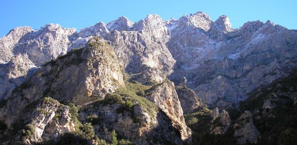
Along a centuries old drovers’ path and trading route in the high sierra above Acebuchal. |
|
Height Gained
|
500 metres (from Acebuchal) |
|
Height Lost
|
500 metres (from mountain inn) |
|
Risk of Vertigo
|
No |
|
Recommendations
|
Trainers, tennis shoes or walking sandals are adequate. However, no flip-flops or similar, please. Good level of fitness required. Bring something to eat as an on-route snack (nuts, dried fruit, chocolate bars, etc.) sufficient water for the day and appropriate clothing for the weather and prevailing seasonal conditions. |
|
Additional Gear
|
Camera. |
|
Highlights
|
Walk in the footsteps of muleteers, drovers, bandits, guerilleros and Franco’s civil guard. Convoy support provided by pack mules. Reenactment of a muleteer trading convoy along a section of a centuries old historic trading route. Typical Axarquian style lunch in the mountains. Stories, tales and anecdotes of some of the most important historical events and incidents to have occurred in the mountains during the last century. |
|
Facilities
|
Lavatory, food and drinks available at the restaurant in El Acebuchal. |
|
Observations
|
None. |
Historical background
There is a bewildering network of trails and paths throughout the mountains just behind Nerja and Frigiliana. Most of these centuries-old paths date back to at least the beginning of Arab times during the 8th and 9th centuries, with some believed to date to even earlier periods – a consequence of the many different economic, commercial and social activities, customs and lifestyles that were prevalent in the region over the centuries. Some of these paths are still existent and in use to this day, while others have long been abandoned and have disappeared through disuse.
The most important and prominent of these paths are those of the old trading routes that form a direct connection between the villages on the Mediterranean coast and the higher Axarquía, and the town of Alhama de Granada and the city of Granada to the north on the other side of the Sierra Almijara mountain range, with the path continuing further northwards still to the province of Jaén. Our walk takes us along one of the most important of the six principal trading routes, conveniently stopping short of one of the most difficult sections of all, the formidable and narrow stretch leading up to the high Frigiliana Pass at a height of 1200 metres.
Though difficult and extremely dangerous the journey was, through their incessant presence, the muleteers kept the trails clean, open and in constant operation. Such was the frenetic activity through the mountains that many strategically positioned inns and taverns provided a welcome service to the weary traders and other travellers. Perishable loads obliged the muleteers to conduct the journey almost exclusively at night; whether summer or winter; full moon or new moon; through driving rain and snow, howling wind or ice. Any journey made during the heat of the day would certainly result in a severe deterioration of their delicate and vulnerable merchandise and a much less marketable product once arrived at their destination.
Similar to the muleteers, a vast and intricate network of trails and paths was also established and used by the maquis, otherwise known as the mountain guerillas or resistance fighters, who fought a long, drawn out battle in opposition to the dictatorship of General Franco during the 1940s and 50s. The maquis used the precipitous and challenging geography to put their fighting strategy to best effect. They created an extensive network of paths and hideouts positioned in specially chosen locations in order to disrupt and disable the superior military presence of the Franco-led forces. By the beginning of the post civil war period, the maquis had already established themselves across most of Spain, with the largest group and most organised resistance hailing from Andalucía which, coincidentally, was home to the strongest, largest, most notorious and dangerous band in all of Spain, and was based right here in the Axarquía and in the Sierras de Tejeda, Almijara y Alhama mountain ranges.
Walk description
The Muleteer Odyssey is an historical “reenactment” of sorts, and a fascinating look (and feel) back in time to what life used to be like in these mountains for the mule drivers of the day: the many challenges, the untold risks, the ever present dangers and the bountiful rewards.
This walk provides an opportunity to experience this unique journey first hand and to learn a little about the history behind this legendary route, and is an experience that will put you in the shoes of a mule driver embarking on such a perilous journey. The section that we will walk is considered the easiest and most exciting section of this long and gruelling +100 kilometre trade route.
During the walk you will hear all of the interesting and fascinating stories about the mountains, the routes, the trials and tribulations of the traders, the guerrillas, the civil war and the Civil Guard, isolated mountain farmsteaders, smugglers, and bandidos, among others who all made their living by exploiting the mountains in one way or another over the course of many centuries.
Most, if not all of the walk, follows a continuously easy gradient along wide open trails, with the exception of two short uphill sections. The first section is at the very start of the walk and is a short stretch of between 10 – 15 minutes’ duration. The second section is immediately before our final destination at the half-way point and lunch spot, and is a slightly longer uphill walk of around 20 – 25 minutes’ duration.
Our convoy consists of sturdy pack mules which will carry our supplies, gear, food, cooking equipment and water for the day. The highlights of the walk are our breakfast and lunch stops at the beginning and end of our walk. Breakfast is at the location of a ruinous inn in a cool mountain valley. Similarly, our lunch stop is at the halfway point of the walk where we will relax and enjoy a typical traveller’s mountain menu on the site of perhaps one of the most historic and famous mountain inns in the sierra. The location, setting and views are absolutely spectacular. This inn, in its heyday, typically served Franco’s military forces by day, and surreptitiously catered to the needs of the maquis under the blanket of darkness at night. Standing on the site, you will appreciate why such dangerous moves were played out. The remoteness, isolation, difficulty of the terrain and the omni-present serenity is captivating. As far as deception, intrigue and mountain warfare strategy goes, it really doesn’t get any better than this!