|
Price
|
€ 25 |
|
Day & Time
|
Thursdays starting at 10:00 (walking calendar) |
|
Meeting Point
|
Nerja bus station, Nerja (map) at 09:30, and then at the Nerja Caves (map) at 10:00. |
|
Minimum Group Size
|
Limited number of spaces available on each walk in order to maintain group safety and good walker/guide ratio. |
|
Start Time
|
10:00 at the Nerja Caves (map) |
|
Finish Time
|
17:00 at the Nerja Caves |
|
Walking Time
|
7 hours (includes stops for breaks, photos, etc.) |
|
Walking Distance
|
16 kilometres (circular route) |
|
Height Gained
|
800 metres (from Nerja Caves) |
|
Level of Difficulty
|
4C (rating explanation). This hike is long and at times suited to those who are very fit, able and seasoned walkers. |
|
Risk of vertigo
|
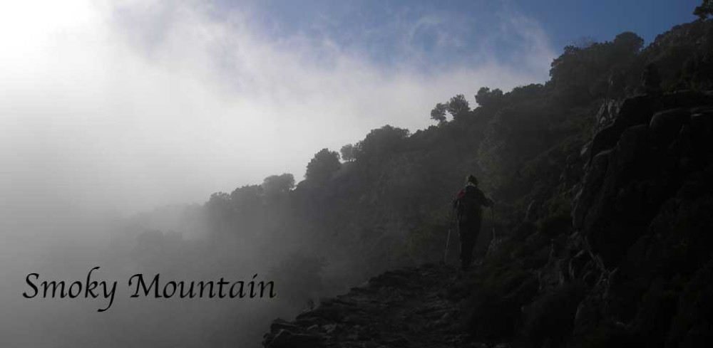
Yes, on a short section of an exposed ridge. |
|
Recommendations
|
Hiking boots or walking shoes with thick socks is highly recommended since much of this walk covers rough and uneven ground. Definitely no flip-flops, sandals or similar, please. A good level of fitness is also required. Bring something to eat for lunch, sufficient water and appropriate clothing. |
|
Additional Gear
|
Walking sticks/poles would be greatly advantageous. |
|
Highlights
|
Very varied walking terrain and scenery ranging from fine pebbled paths and dry riverbeds to pine-cloaked mountain valleys and exposed mountainsides and sheer cliffs. Great views. Resplendent pine forests and wildflowers in spring. An exhilirating hike on a spectacular trail with great scenery. Wildlife spotting possible. Some light scrambling involved on an exposed ridge. |
|
Facilities
|
Lavatory, drinks and food available at the Nerja Caves. |
|
Observations
|
This walk starts at the Nerja Caves at 10:00. Walkers based in Nerja should meet me no later than 09:30 at the Nerja town meeting point (map). Walkers based in Frigiliana who intend to use public transport for getting to the start of this walk should get the 08:00 bus to Nerja and meet the main group at the Nerja town meeting point (map) at 09:30, at which point we will all get the 09:40 bus to the Nerja Caves, where this walk will begin at 10:00. This walk ends at the Nerja Caves at approximately 17:00. Walkers based in Frigiliana will be able to catch the 18:00 bus to Nerja, and then catch the 19:00 bus to get back to Frigiliana. |
|
Map of walking area
|
This is a relatively long but varied hike with a challenging component which involves some scrambling up a short but narrow, rocky ridge in the last section of the ascent to the highest point of the itinerary. Those with vertigo, beware! Apart from this challenging section, the hike is otherwise moderate in difficulty and offers a great opportunity to test and challenge oneself and one’s stamina.
The hike begins with a wonderful walk up a dry riverbed in a picturesque valley through an impressive pine forest of Aleppo Pine, not to mention an infinity of other plant species that inhabit the shady valley floor. Along this part of the walk, squirrels and a multitude of important bird species are known to be prolific. The path continues gently up the valley following the rivercourse, leaving it at a particular point to bob, weave, dip and turn its way up the valley as we follow the contours and terrain of these gentle mountain foothills.
We continue further up the valley and soon begin the most difficult part of the hike. There are moments, however, when one has the opportunity for taking in the wonderful views of numerous mountain peaks that come into view when there is a clearing in the pine forest or an elevated point along the path. The altitude gained at this point is sufficient to afford some views of the pretty scenery around us. As we approach the highest point of our itinerary, the path steepens. There are some short but challenging sections that follow, with some infrequent scrambling where the path becomes difficult to discern and where we must negotiate the most technical section: a rocky outcrop formed into a narrow section of ridge near the highest point of the hike. The ridge is not without its rewards, as it provides a great opportunity to take photos of the vistas, typified by sheer cliffs and steep, rugged mountain slopes within the immediate vicinity, to a vast panorama of lush, pine-covered mountain valleys in the distance with the blue waters of the Mediterranean sea in the background.
After traversing the rocky outcrop, we soon approach the halfway mark and the highest point of our itinerary, and a suitable point at which to stop for a well deserved break for lunch and some well-earned rest. After lunch, we take a leisurely hike back down to Maro along the upper slopes of an adjacent valley with lovely views. This section of the hike is very pleasant as the descent down the mountainside is gradual and along well-groomed forest trails and paths. The gorgeous scenery of pine-covered mountain slopes and wide valleys will add to the enjoyment of the return leg. There are some sections where we will have nice views across the valley as we follow the trail down. We should get back to the Nerja Caves by 17:00.