|
Price
|
€ 25 per person |
|
Day & Time
|
Thursdays starting at 10:00 (walking calendar) |
|
Meeting Point
|
Nerja bus station, Nerja (map) at 09:30, and then at the main Frigiliana bus stop, Frigiliana (map) at 10:00. |
|
Minimum Group Size
|
Limited number of spaces available on each walk in order to maintain group safety and good walker/guide ratio. |
|
Start Time
|
10:00 at the main Frigiliana bus stop, Frigiliana (map) |
|
Finish Time
|
16:00 at the main Frigiliana bus stop, Frigiliana |
|
Walking Time
|
5 – 6 hours (includes stops for breaks, lunch, photos, etc.) |
|
Walking Distance
|
14 kilometres (linear route) |
|
Height Gained
|
650 metres (from Frigiliana village) |
|
Level of Difficulty
|
4C (rating explanation) |
|
Risk of vertigo
|
Some risk on the peak itself, if one ventures to the edges. |
|
Recommendations
|
Hiking boots or walking shoes with thick socks recommended. Trainers/tennis shoes may also be suitable; however, no flip-flops , beach slippers or similar, please. A decent level of fitness is also required. Bring something to eat for lunch, sufficient water and wear appropriate clothing. |
|
Aditional Gear
|
Walking sticks/poles would be useful. |
|
Highlights
|
Excellent 360 degree views. Historical site on summit. |
|
Facilities
|
Lavatory, drinks and food available at Frigiliana. |
|
Observations
|
This walk starts in Frigiliana at 10:00 at the main Frigiliana bus stop in the centre of the village (map). Walkers based in Nerja should meet me no later than 09:30 at the Nerja town meeting point (map). We will catch the 09:45 bus for Frigiliana and meet the Frigiliana group at the Frigiliana meeting point at approximately 10:00, when this walk will begin. |
|
Map of walking area
|
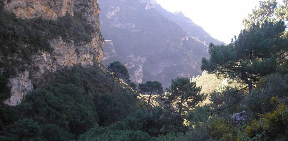
The walk to El Fuerte (The Fort) though relatively short, is an unrelenting climb, albeit to a modest and unassuming summit, of which once at the top, arguably has one of the most enviable vantage points in the Almijara range. The route represents by far the shortest walk from Frigiliana to a worthy peak, and although the going can be tough, the spectacular 360 degree scenic panorama makes it well worth the effort of getting there and affords a bewildering display of almost all of the emblematic and prominent peaks and natural landmarks of the Natural Park.
Shortly after leaving Frigiliana, we arrive at a small plateau and the ruins of what was once a 9th century arab castle which directly overlooked the village and which was eventually destroyed in the 16th century. After a short rest here, we leave the castle remains and begin the hard work of the ascent to El Fuerte. Looking up in front of us, we can appreciate the long and pronounced ridge of El Fuerte, splitting the landscape into two, with the stark and rugged Rio Higuerón valley to the right, and to the left, the Río Seco and Torrox valleys.
The route is not without its challenges, not least because of the incessant and unyielding incline at practically every moment along the way. The characteristics of the terrain underfoot also make the job difficult. Thus, good sturdy walking boots or shoes with a good sole are essential as there are numerous sections where the combination of loose stones, exposed tree roots, smooth rocky outcrops and the incline together require concentration and prudence to avoid slips, trips and falls on the path. Having walking sticks would be an advantage on this walk, especially on the descent.
At a certain along the route, there is a clearing where we can enjoy a spectacular view of Frigiliana village and Nerja on the coast. As we carry on a little higher again, we come to another look out point where we have another perspective of the Río Higuerón valley, but only this time, with the additional spectacle of an array of some magnificent peaks of the Almijara range, which includes, among others, the iconic Cielo (1,508m).
As we continue higher still, more peaks come into view, one of the most distinctive being the unmistakable Lucero (1,779m). Getting nearer to the top of El Fuerte, through another clearing we can see the summit at close hand and notice two distinct peaks; the higher one to the right (1,007m) and our objective to the left with the triangulation station on its highest point(979m). From here we also gain another view of Lucero, together with its three neighbouring peaks of Cerro de los Mosquitos (1,687m), Cerro de La Mota (1,649m) and Lomas de La Mota (1,671m).
Once at the top of El Fuerte, the panoramic assault is nothing less than spectacular, with an array of peaks all around us. Looking west and immediately below is the hamlet of El Acebuchal, and beyond that, the upper Patamalara river valley which is an extension of the Torrox valley. We can also see the towns and villages of Maro, Torrox, Nerja, Torre del Mar, and even as far afield as Málaga, the mountains of Mijas, the distant Sierra de las Nieves (Ronda) which can be seen with its snow-capped high ground in the winter, and of course, the king of the entire range and Natural Park, La Maroma (2,065m).
The summit of El Fuerte was also the site of another arab castle, destroyed by the Christians in the 16th century, of which only traces of its foundations are all that remain. After a well-deserved rest and break for lunch, and having taken in the wonderful views, we will begin our return to Frigiliana, getting back into Frigiliana at around 16:00.
Click here to enquire or book this walk!