NEW ADVENTURE TREK!
|
Level of Difficulty
|
5 D – E (rating explanation) |
|
Price
|
€ 40 per person |
|
Day & Time
|
See walking calendar |
|
Meeting Point
|
Nerja bus station, Nerja (map) at 07:30 |
|
Start Time
|
Pinarillo picnic area at 08:00 |
|
Finish Time
|
Pinarillo picnic area at 20:00 |
|
Minimum Group Size
|
None |
|
Maximum Group Size
|
Limited number of spaces available on each walk in order to maintain group safety and good walker/guide ratio. |
|
Walking Time
|
>10 hours (includes stops for breaks, photos, lunch, etc.) |
|
Walking Distance
|
22 kilometres (circular route) |
|
Route location
|
In the high sierra to the north of the village of Maro. |
|
Height Gained
|
1300 metres |
|
Risk of vertigo
|
Some risk. Please enquire for details. |
|
Recommendations
|
Walking/hiking boots are best. Trainers or tennis shoes acceptable but highly unadvisable. Do so at your own risk. Excellent level of fitness required. Bring a packed lunch, snacks, nuts, dried fruit, sufficient water for the day and appropriate clothing for the walking and weather conditions. |
|
Additional Gear
|
Depends on the season and conditions. General: walking poles, headlamp/torch with spare batteries, lip balm, sunglasses, hat/cap. Autumn & Spring: suncream, minimum 3 -4 litres of water, light and loose clothing, waterproofs. Winter: minimum 3 litres of water, wooly hat, gloves, neck warmer, baselayers, fleece, waterproofs. |
|
Highlights
|
Ascend two iconic peaks in one day, which includes one of the highest peaks in the entire range and the highest in the Sierra Almijara: Navachica (1831m). An extremely rewarding trek affording spectacular views of the mighty Sierra Nevada in Granada, and the highest peak in the Sierras Tejeda, Almijara y Alhama range, La Maroma (2068m), among many others. |
|
Facilities
|
Lavatory, food and drinks available only at Maro and Nerja. |
|
Observations
|
Impressive scenery: camera a must. |
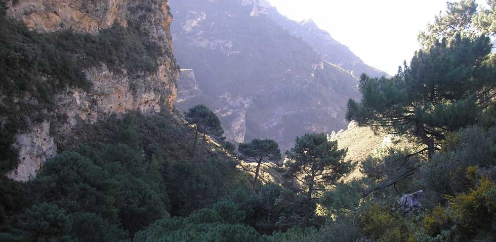
Simply put, this is an all-encompassing trek, bearing all of the characteristic hallmarks of a grand one-day trekking adventure. We navigate through hugely varied mountain environments and spectacular landscapes ranging from wooded, warm, low mountain valleys to barren, cold, windswept alpine mountain environments. We must also contend with a huge variety of terrain ranging from well groomed forest trails, to steep, precipitous rocky paths, sometimes with no paths at all. The trek has a high level of difficulty and is recommended for only the most seasoned and hardy of hikers and trekkers. The trek is considered challenging, not only because it is long and steep, but because of the arduousness of the terrain underfoot, which makes progress slow and difficult.
The trek starts at the Pinarillo picnic area at the start of the Cazadores valley. The walk up the valley from our starting point is pleasant along relatively easy terrain. At the same time it is spectacularly impressive, for we soon find ourselves walking along a deep gorge with spectacular vertical crags, some of which are hundreds of metres high. As we move up the valley, the landscape is nothing short of spectacular. The many spurs, crags and steeply sloping mountainsides make for a wonderful walking experience. Moving further up the valley we come up to some old abandoned mines, interesting relics and the evidence of a hive of activity that predominated in the Cazadores valley up until the 60s.
From this point on, the trek becomes notably difficult. The path follows an ever steeper and narrower river valley. There is a continuous slow hard climb up the valley until we eventually come out of the tree line below the relatively flat crest of the Navachica plateau. As we make our long approach to the summit along the barren convex flank, more peaks and features begin to come into view from the west and south. As we ascend towards the summit, the emerging views from atop the plateau and crest are amazing, with many prominent peaks of the Sierras Tejeda, Almijara y Alhama Natural Park become visible. Soon we arrive at the summit itself, the highest point in the Sierra Almijara, and one of the most revered treks and summits of the entire Natural Park.
From the summit of Navachica, the views are some of the best and most spectacular you will ever possibly see. From this vantage point, one can also see the impressive Sierra Nevada, the ranges of Huétor, Mágina, Gádor y Contraviesa. On clear days, one can also see the ranges of Mijas, sierra de las Nieves and even Sierra Bermeja. After a satisfying rest and moments of appreciation of the spectacular panorama on the summit, we turn our attention to our second objective and the summit of El Cielo, a seven kilometre walk away. This part of the trek is the most physically enjoyable because we follow a very gentle descent along the Navachica easterly ridge, enjoying panoramic vistas along its entire length on our approach to El Cielo. On reaching Cielo, the views of the coast and surrounding lower mountain valleys are equally as impressive as Navachica’s. The summit provides yet another well-earned opportunity for a rest and a replenishment of energy levels before beginning our final descent down the precipitous west face of El Cielo until eventually arriving at the foot of El Cielo and our original starting point.